Hi, Gilly here. I haven’t had a new route for a while, so I thought I would treat you this month! While chatting with Maria Genoveva from the sports department at Lagos City Hall, I was introduced to a route that was not on my radar. Not surprising as it is not marked, it is a GPS-only route (not physically signposted) – more about that, but first, the route:
Rota do Barrocal
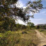
Named after the geological region that runs between the mountains and the coast in the central and eastern regions of the Algarve, the Rota do Barrocal is an intermediate level, all-terrain (roads and trails) linear route. It is 223 km long, running through small and traditional villages and towns. Due to the geography and the terrain (it doesn’t look like there are many climbs), it can be cycled both east to west and west to east between Vila Real de Santo António and Aljezur.
The Barrocal has significant ecological, historical, and cultural importance. Its limestone soil provides a rich environment for vineyards and almond groves alongside mixed dryland orchards of olive, fig and carob; there are beautiful landscapes, a variety of birdlife and varied architecture, including Roman and Moorish ruins – sounds brilliant!

Now for the GPS bit … Call me a traditionalist, but I do love a map and the freedom of exploring. I also really appreciate the wonderful, marked routes we have on our doorstep. So I haven’t felt the need, until now, to get on board with GPS routes, so a good place to start was understanding the terminology:
GPS is the system that gives us the capability. Global Positioning System is a series of navigation satellites which circle the earth and send out signals which can be picked up using a GPS-receiving device to show you accurately and in real-time where you are.
GPS-receiving device – is the tech we need to follow a route. Most of us have GPS on our smartphones, which we use to show us exactly where we are on apps such as Google Maps or Strava. Cyclists often use sport-specific GPS-receiving devices, such as Garmin, to record their rides, routes and data.
GPS route – this is the route that has been created by other riders and individuals. It is an ordered list of coordinates in a computerised mapping system, which can then be saved as a GPX file. GPX is a standard electronic route publishing format that allows the route to be downloaded and shared.
GPX route or GPX file – is the electronic document we need to download. There are lots of GPX files which can be downloaded for free – once you start looking, brace yourself, it opens up a whole new world of routes and possibilities.
GPX viewer app – is a software application you need to download to your phone. There are lots of paid-for services and free apps for Android and iOS, such as Strava, Komoot, AllTrails etc. Once you have downloaded one, you will be able to find and upload your saved GPX file, read and follow it. GPS-receiving devices will automatically have this software.

Feeling enlightened, my next task was to work out how I could follow the Rota do Barrocal – I found the GPX file for this route at www.visitalgarve.pt
Everything I was reading suggested the most straightforward process would be to use my smartphone, find and download the GPX file via the internet, then upload it into my chosen GPX viewer app. However, I wanted to use my Garmin. This process was slightly different but still straightforward. I used my laptop to find the route on the internet, I downloaded the GPX file and imported it into my Garmin account. I connected my device with my laptop and transferred the file. When I was ready to roll, I simply selected the route on my device and instructed it to start navigating – happy days, now to get used to using the device and spending the autumn exploring the route.


As with all equipment and technology, there are limitations and potential problems, so it is worth noting:
GPS-receiving devices have to run for many hours without a power supply or being charged, be user-friendly when you are riding and wearing gloves, and work in the rain! So whilst similar, they are not as comprehensive as the larger, higher definition in-car systems.
Devices can run out of power on longer rides, so remember to charge them fully and take a portable charger and/or a backup paper map.
Sometimes obstacles can impact the accuracy of your GPS location and track conditions may have changed or re-routed from when a route was originally recorded, so keep your wits about you.
If this has inspired you to get out and explore the Barrocal, as always, have fun and stay safe.
If you try all or part of this route, I would love to hear about your experience, get in touch at bikinginthealgarve@gmail.com